


Contact Us
Home » LiDAR » Richmond, BC
Explore the unseen with LiDAR mapping—contact us for pricing.
LiDAR in Richmond, BC
Book Your Appointment
Please Fill Put This Form Below, We Will Address Your Query within 24hrs
About Us
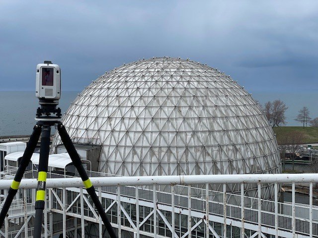
3DS Technologies is dedicated to delivering accurate and actionable spatial data for a wide range of projects, combining advanced technology with hands-on expertise. Our team approaches every assignment with precision, ensuring clarity and reliability in all measurements. Based in Richmond, BC, we provide trusted services to engineers, architects, and planners who need dependable spatial data. Across Richmond, BC and surrounding areas, we help clients turn complex environments into clear, usable insights. Using lidar, we capture spaces with meticulous care and transform them into digital models for better planning. Every project is approached with transparency, focus, and a human-centered mindset. Our professionals make sure that every scan is accurate, repeatable, and meaningful for real-world applications. Trust, reliability, and clear communication guide all interactions with clients. 3DS Technologies acts as a partner in success, not just a service provider. We pride ourselves on delivering precision, clarity, and measurable results in every assignment.
Client Testimonials
Real Stories from Our Happy Customers
Posted on![]()
![Dennis Johnsen profile picture]() Dennis Johnsen
Dennis JohnsenTrustindex verifies that the original source of the review is Google.
I am very happy with the work done by 3DS Technologies. I was looking to rent equipment, and for about the same price I got the scans indexed together, a viewer program, and many more scans in less than 1/3 of the time I would have taken to just do the scans myself. It imported as 1 file into Navisworks and could be edited in there. I look forward to working with 3DS Technologies in the future! Dennis.Posted on![]()
![Amanda Fernandes profile picture]() Amanda Fernandes
Amanda FernandesTrustindex verifies that the original source of the review is Google.
We used 3DS for a 3D scan of a building we were designing a renovation for. The scans were accurate and delivered on time. By being able to utilize the 3D scan it reduced our field visit times significantly. We will definitely use them again.Posted on![]()
![Ashley Gibson profile picture]() Ashley Gibson
Ashley GibsonTrustindex verifies that the original source of the review is Google.
Very professional team! I would recommend their 3D laser scanning services.Posted on![]()
![FABRIK Architects inc. profile picture]() FABRIK Architects inc.
FABRIK Architects inc.Trustindex verifies that the original source of the review is Google.
3DS Technologies has completed one project with us and we were very satisfied with the results! They accommodated our tight project deadline, and delivered a quality 3D Revit model for our office to use. We hope to engaged them for future projects.Posted on![]()
![Ron TWD profile picture]() Ron TWD
Ron TWDTrustindex verifies that the original source of the review is Google.
Great to work with, quick response time, flexible, laser scan quality very high with competitive prices.Posted on![]()
![Rob Abell profile picture]() Rob Abell
Rob AbellTrustindex verifies that the original source of the review is Google.
Fast & Great service. defiantly would suggest 3DS for any project large or small.Posted on![]()
![Stewart Bowland profile picture]() Stewart Bowland
Stewart BowlandTrustindex verifies that the original source of the review is Google.
3DS Technologies did everything we asked them to do and more. They responded to all our requests in a timely fashion, were professional in all our dealings with them and with our customers and were always available to help with questions or concerns. If you have a requirement for 3D scanning, I highly recommend 3DS Technologies.
Get Started
Explore LiDAR Services in Richmond, BC and Surrounding Communities

Explore LiDAR Services in Richmond, BC and Surrounding Communities
Our lidar solutions provide detailed spatial data to support construction, design, and restoration projects in Richmond, BC and nearby areas. Surrounding communities rely on our expertise to capture complex spaces with accuracy and reliability. Each scan is carefully conducted and interpreted to provide actionable insights for engineers, architects, and planners. Clients benefit from data that improves workflows, minimizes mistakes, and streamlines project planning. We adapt to site-specific conditions, ensuring measurements are precise and meaningful. Our approach emphasizes usability, translating detailed scans into information that informs decisions. By integrating lidar into projects, stakeholders can make confident choices and reduce costly rework. Every assignment is treated with care, tailored to client requirements, and delivered with actionable results. The technology bridges the gap between physical spaces and digital planning tools. Precision, clarity, and reliability remain central to our services across all surrounding regions.
Innovative Solutions for Accurate Spatial Data Capture and Project Efficiency

Innovative Solutions for Accurate Spatial Data Capture and Project Efficiency
Every project comes with unique challenges, and our approach focuses on delivering precise, usable data to support critical decisions. Using advanced lidar technology, we collect measurements that translate complex environments into actionable insights. Our team carefully assesses each site to understand conditions and requirements before scanning, ensuring results are reliable and practical. Measurements are interpreted to provide clear information for design, planning, and restoration tasks. Collaboration throughout the workflow ensures stakeholders remain aligned and confident in each stage. We prioritize clarity, accuracy, and efficiency to make data easily usable for project teams. Techniques are continuously refined to meet the demands of different environments and unforeseen challenges. Every scan is produced with attention to detail and practical application in mind. Our methodical approach improves project timelines while maintaining high standards of accuracy. The result is reliable, understandable data that supports informed decision-making for every client.
Why Work With 3DS Technologies for LiDAR in Richmond, BC
Why Work With 3DS Technologies for LiDAR in Richmond, BC
Choosing 3DS Technologies ensures precise lidar measurements that provide confidence and informed decision-making in Richmond, BC. Our team combines advanced technology with expertise to deliver accurate and actionable results for every project. Clients trust 3DS Technologies because we consistently provide reliable outcomes that reduce errors and enhance workflow efficiency. Each assignment is tailored to site-specific conditions to maximize relevance and usability. In Richmond, BC, our services support architects, engineers, and planners who require dependable spatial data. Communication and transparency guide every step, keeping stakeholders informed throughout the process. We stand out by treating each project as unique, ensuring data is accurate and easy to interpret. 3DS Technologies emphasizes accountability, professionalism, and a human-centered approach in every task. Partnering with us gives clients clarity, reliability, and peace of mind for every project. Our dedication ensures lidar consistently delivers precise, high-quality outcomes that drive successful project execution.
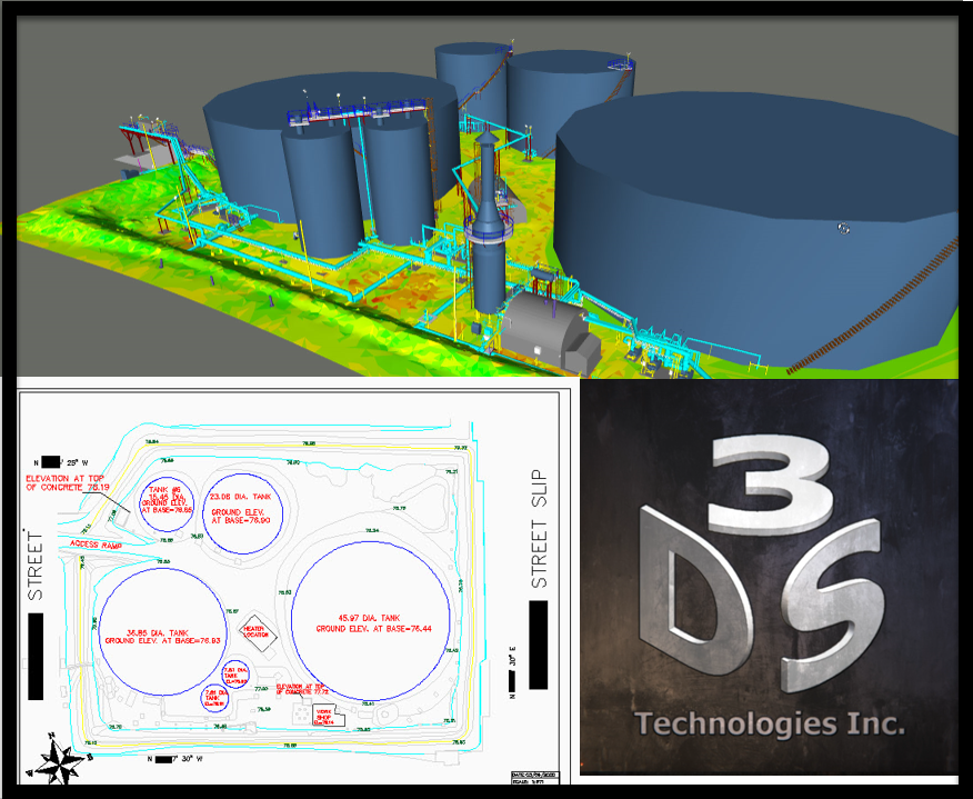
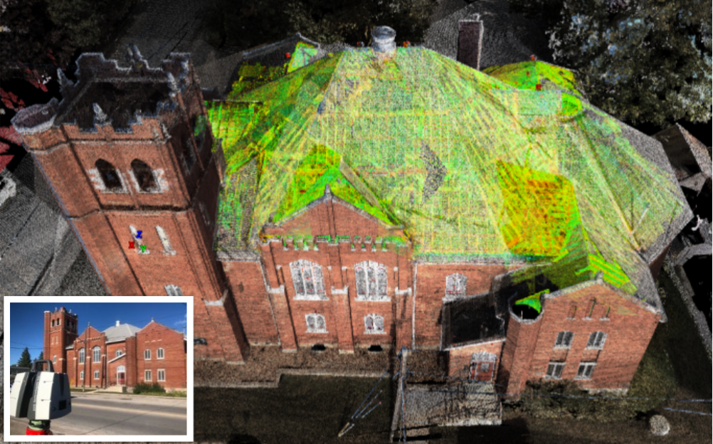
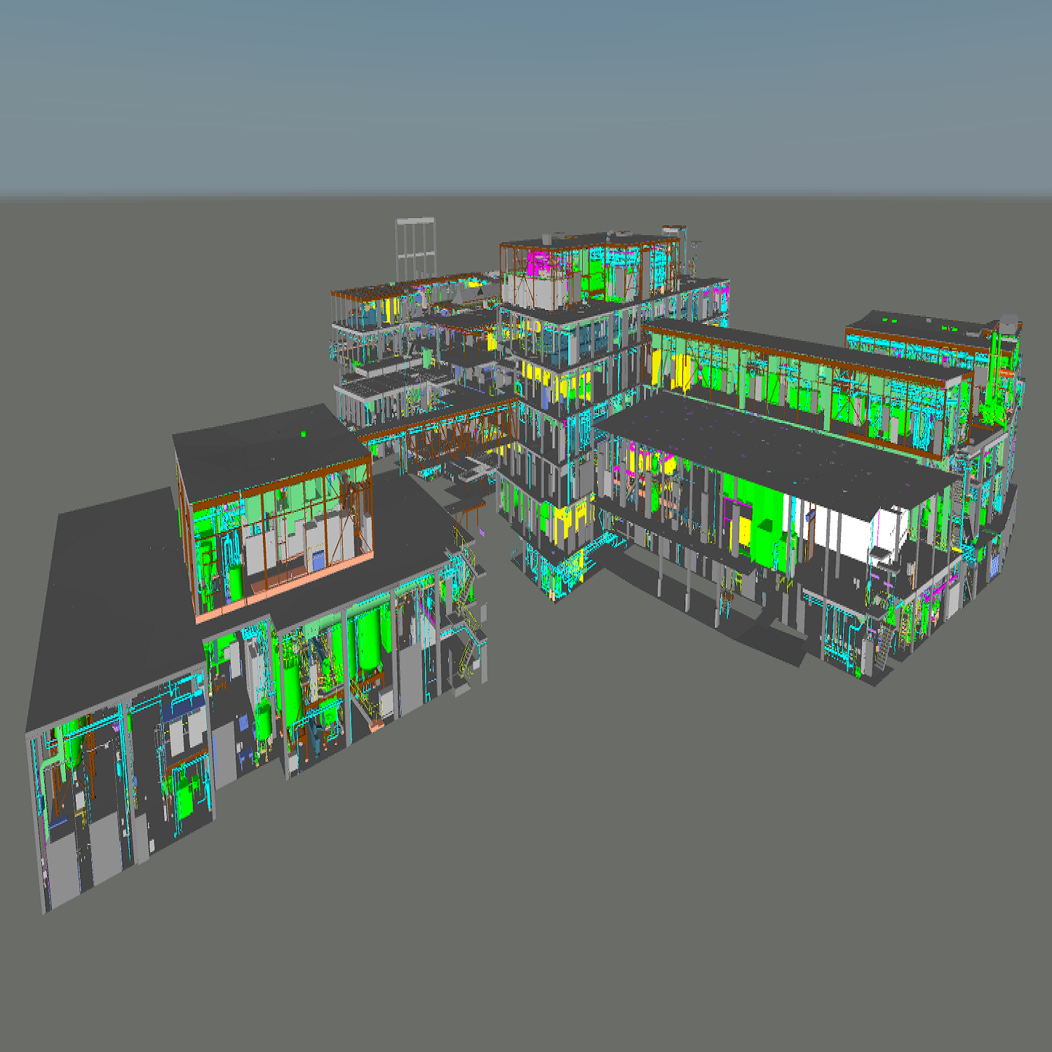
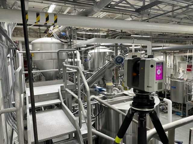
Our Gallery
Directory Of Services
- 3D Laser Scanning in Mississauga, ON
- 3D Laser Scanning in Etobicoke, ON
- 3D Laser Scanning in Brampton, ON
- 3D Laser Scanning in Scarborough, ON
- 3D Laser Scanning in Oakville, ON
- 3D Laser Scanning in Stoney Creek, ON
- 3D Laser Scanning in Hamilton, ON
- 3D Laser Scanning in Ottawa, ON
- 3D Laser Scanning in Kingston, ON
- 3D Laser Scanning in Barrie, ON
- 3D Laser Scanning in Windsor, ON
- 3D Laser Scanning in Kitchener, ON
- 3D Laser Scanning in Cambridge, ON
- 3D Laser Scanning in Waterloo, ON
- 3D Laser Scanning in Niagara Falls, ON
- 3D Laser Scanning in Calgary, AB
- 3D Laser Scanning in Edmonton, AB
- 3D Laser Scanning in Vancouver, BC
- 3D Laser Scanning in Victoria, BC
- 3D Laser Scanning in Kelowna, BC
- 3D Laser Scanning in Richmond, BC
- 3D Laser Scanning in Surrey, BC
- 3D Laser Scanning in Abbotsford, BC
- 3D Laser Scanning in Saskatoon, SK
- 3D Laser Scanning in Regina, SK
- 3D Laser Scanning in Winnipeg, MB
- 3D Laser Scanning in Halifax, NS
- 3D Laser Scanning in Miami, FL
- 3D Laser Scanning in Jacksonville, FL
- 3D Laser Scanning in Orlando, FL
- 3D Laser Scanning in Bradenton, FL
- 3D Laser Scanning in Tampa, FL
- 3D Laser Scanning in Fort Lauderdale, FL
- 3D Laser Scanning in Charlotte, NC
- 3D Laser Scanning in Houston, TX
- 3D Laser Scanning in Dallas, TX
- 3D Laser Scanning in Chicago, IL
- 3D Laser Scanning in Guelph, ON
- 3D Scanning in Mississauga, ON
- 3D Scanning in Etobicoke, ON
- 3D Scanning in Brampton, ON
- 3D Scanning in Scarborough, ON
- 3D Scanning in Oakville, ON
- 3D Scanning in Stoney Creek, ON
- 3D Scanning in Hamilton, ON
- 3D Scanning in Ottawa, ON
- 3D Scanning in Kingston, ON
- 3D Scanning in Barrie, ON
- 3D Scanning in Windsor, ON
- 3D Scanning in Kitchener, ON
- 3D Scanning in Cambridge, ON
- 3D Scanning in Waterloo, ON
- 3D Scanning in Niagara Falls, ON
- 3D Scanning in Calgary, AB
- 3D Scanning in Edmonton, AB
- 3D Scanning in Vancouver, BC
- 3D Scanning in Victoria, BC
- 3D Scanning in Kelowna, BC
- 3D Scanning in Richmond, BC
- 3D Scanning in Surrey, BC
- 3D Scanning in Abbotsford, BC
- 3D Scanning in Saskatoon, SK
- 3D Scanning in Regina, SK
- 3D Scanning in Winnipeg, MB
- 3D Scanning in Halifax, NS
- 3D Scanning in Miami, FL
- 3D Scanning in Jacksonville, FL
- 3D Scanning in Orlando, FL
- 3D Scanning in Bradenton, FL
- 3D Scanning in Tampa, FL
- 3D Scanning in Fort Lauderdale, FL
- 3D Scanning in Charlotte, NC
- 3D Scanning in Houston, TX
- 3D Scanning in Dallas, TX
- 3D Scanning in Chicago, IL
- 3D Scanning in Guelph, ON
- 3D Scan in Mississauga, ON
- 3D Scan in Etobicoke, ON
- 3D Scan in Brampton, ON
- 3D Scan in Scarborough, ON
- 3D Scan in Oakville, ON
- 3D Scan in Stoney Creek, ON
- 3D Scan in Hamilton, ON
- 3D Scan in Ottawa, ON
- 3D Scan in Kingston, ON
- 3D Scan in Barrie, ON
- 3D Scan in Windsor, ON
- 3D Scan in Kitchener, ON
- 3D Scan in Cambridge, ON
- 3D Scan in Waterloo, ON
- 3D Scan in Niagara Falls, ON
- 3D Scan in Calgary, AB
- 3D Scan in Edmonton, AB
- 3D Scan in Vancouver, BC
- 3D Scan in Victoria, BC
- 3D Scan in Kelowna, BC
- 3D Scan in Richmond, BC
- 3D Scan in Surrey, BC
- 3D Scan in Abbotsford, BC
- 3D Scan in Saskatoon, SK
- 3D Scan in Regina, SK
- 3D Scan in Winnipeg, MB
- 3D Scan in Halifax, NS
- 3D Scan in Miami, FL
- 3D Scan in Jacksonville, FL
- 3D Scan in Orlando, FL
- 3D Scan in Bradenton, FL
- 3D Scan in Tampa, FL
- 3D Scan in Fort Lauderdale, FL
- 3D Scan in Charlotte, NC
- 3D Scan in Houston, TX
- 3D Scan in Dallas, TX
- 3D Scan in Chicago, IL
- 3D Scan in Guelph, ON
- LiDAR in Mississauga, ON
- LiDAR in Etobicoke, ON
- LiDAR in Brampton, ON
- LiDAR in Scarborough, ON
- LiDAR in Oakville, ON
- LiDAR in Stoney Creek, ON
- LiDAR in Hamilton, ON
- LiDAR in Ottawa, ON
- LiDAR in Kingston, ON
- LiDAR in Barrie, ON
- LiDAR in Windsor, ON
- LiDAR in Kitchener, ON
- LiDAR in Cambridge, ON
- LiDAR in Waterloo, ON
- LiDAR in Niagara Falls, ON
- LiDAR in Calgary, AB
- LiDAR in Edmonton, AB
- LiDAR in Vancouver, BC
- LiDAR in Victoria, BC
- LiDAR in Kelowna, BC
- LiDAR in Richmond, BC
- LiDAR in Surrey, BC
- LiDAR in Abbotsford, BC
- LiDAR in Saskatoon, SK
- LiDAR in Regina, SK
- LiDAR in Winnipeg, MB
- LiDAR in Halifax, NS
- LiDAR in Miami, FL
- LiDAR in Jacksonville, FL
- LiDAR in Orlando, FL
- LiDAR in Bradenton, FL
- LiDAR in Tampa, FL
- LiDAR in Fort Lauderdale, FL
- LiDAR in Charlotte, NC
- LiDAR in Houston, TX
- LiDAR in Dallas, TX
- LiDAR in Chicago, IL
- LiDAR in Guelph, ON
- Building Information Modeling in Mississauga, ON
- Building Information Modeling in Etobicoke, ON
- Building Information Modeling in Brampton, ON
- Building Information Modeling in Scarborough, ON
- Building Information Modeling in Oakville, ON
- Building Information Modeling in Stoney Creek, ON
- Building Information Modeling in Hamilton, ON
- Building Information Modeling in Ottawa, ON
- Building Information Modeling in Kingston, ON
- Building Information Modeling in Barrie, ON
- Building Information Modeling in Windsor, ON
- Building Information Modeling in Kitchener, ON
- Building Information Modeling in Cambridge, ON
- Building Information Modeling in Waterloo, ON
- Building Information Modeling in Niagara Falls, ON
- Building Information Modeling in Calgary, AB
- Building Information Modeling in Edmonton, AB
- Building Information Modeling in Vancouver, BC
- Building Information Modeling in Victoria, BC
- Building Information Modeling in Kelowna, BC
- Building Information Modeling in Richmond, BC
- Building Information Modeling in Surrey, BC
- Building Information Modeling in Abbotsford, BC
- Building Information Modeling in Saskatoon, SK
- Building Information Modeling in Regina, SK
- Building Information Modeling in Winnipeg, MB
- Building Information Modeling in Halifax, NS
- Building Information Modeling in Miami, FL
- Building Information Modeling in Jacksonville, FL
- Building Information Modeling in Orlando, FL
- Building Information Modeling in Bradenton, FL
- Building Information Modeling in Tampa, FL
- Building Information Modeling in Fort Lauderdale, FL
- Building Information Modeling in Charlotte, NC
- Building Information Modeling in Houston, TX
- Building Information Modeling in Dallas, TX
- Building Information Modeling in Chicago, IL
- Building Information Modeling in Guelph, ON
Frequently asked questions
- How do engineers validate LiDAR data accuracy?
Engineers validate LiDAR data accuracy by comparing it against control points and conducting statistical error analysis. Calibration routines and redundant passes are often used to ensure high confidence in final datasets.
- How is LiDAR used in flood risk management?
LiDAR supports flood risk management by mapping elevation gradients and drainage patterns, helping design resilient infrastructure.
- Can airborne LiDAR measure vegetation density effectively?
Airborne LiDAR measures vegetation density by analyzing pulse returns that penetrate canopy layers. It helps ecologists estimate biomass, monitor deforestation, and assess ecosystem health.
- How accurate is point cloud data for underground mapping?
Point cloud data can achieve remarkable accuracy in underground mapping when combined with inertial navigation. It’s used for mines, subways, and tunnel infrastructure with minimal deviation.
- How is LiDAR transforming land survey accuracy across Richmond, BC and surrounding communities?
LiDAR transforms land survey accuracy in Richmond by generating highly detailed elevation models that support precise boundary definition and flood risk evaluation.