


Contact Us
Home » LiDAR » Jacksonville, FL
Explore structural accuracy with LiDAR technology—get in touch.
LiDAR in Jacksonville, FL
Book Your Appointment
Please Fill Put This Form Below, We Will Address Your Query within 24hrs
About Us
At 3DS Technologies, we provide professional LiDAR services designed to deliver accurate and actionable data for any project. Based in Jacksonville, FL, our team combines advanced technology with practical expertise to ensure precise results. Serving clients across Jacksonville, FL and surrounding areas, we focus on trust, quality, and seamless communication. Every project is carefully managed from initial consultation to final deliverables, ensuring smooth execution and attention to detail. Our solutions are tailored to meet the needs of construction, architecture, and engineering projects. We emphasize efficiency while maintaining meticulous standards of accuracy. By blending innovative technology with hands-on experience, we help clients make informed decisions confidently. Each engagement is handled professionally, providing clarity and reliability throughout. Partnering with 3DS Technologies means gaining a team committed to long-term success. Our goal is to simplify complex workflows while delivering measurable value to every client.
Client Testimonials
Real Stories from Our Happy Customers
Posted on![]()
![Dennis Johnsen profile picture]() Dennis Johnsen
Dennis JohnsenTrustindex verifies that the original source of the review is Google.
I am very happy with the work done by 3DS Technologies. I was looking to rent equipment, and for about the same price I got the scans indexed together, a viewer program, and many more scans in less than 1/3 of the time I would have taken to just do the scans myself. It imported as 1 file into Navisworks and could be edited in there. I look forward to working with 3DS Technologies in the future! Dennis.Posted on![]()
![Amanda Fernandes profile picture]() Amanda Fernandes
Amanda FernandesTrustindex verifies that the original source of the review is Google.
We used 3DS for a 3D scan of a building we were designing a renovation for. The scans were accurate and delivered on time. By being able to utilize the 3D scan it reduced our field visit times significantly. We will definitely use them again.Posted on![]()
![Ashley Gibson profile picture]() Ashley Gibson
Ashley GibsonTrustindex verifies that the original source of the review is Google.
Very professional team! I would recommend their 3D laser scanning services.Posted on![]()
![FABRIK Architects inc. profile picture]() FABRIK Architects inc.
FABRIK Architects inc.Trustindex verifies that the original source of the review is Google.
3DS Technologies has completed one project with us and we were very satisfied with the results! They accommodated our tight project deadline, and delivered a quality 3D Revit model for our office to use. We hope to engaged them for future projects.Posted on![]()
![Ron TWD profile picture]() Ron TWD
Ron TWDTrustindex verifies that the original source of the review is Google.
Great to work with, quick response time, flexible, laser scan quality very high with competitive prices.Posted on![]()
![Rob Abell profile picture]() Rob Abell
Rob AbellTrustindex verifies that the original source of the review is Google.
Fast & Great service. defiantly would suggest 3DS for any project large or small.Posted on![]()
![Stewart Bowland profile picture]() Stewart Bowland
Stewart BowlandTrustindex verifies that the original source of the review is Google.
3DS Technologies did everything we asked them to do and more. They responded to all our requests in a timely fashion, were professional in all our dealings with them and with our customers and were always available to help with questions or concerns. If you have a requirement for 3D scanning, I highly recommend 3DS Technologies.
Get Started
Discover Precision LiDAR Services in Jacksonville, FL and Surrounding Areas

Discover Precision LiDAR Services in Jacksonville, FL and Surrounding Areas
Our LiDAR solutions in Jacksonville, FL and nearby communities provide highly accurate data for diverse projects. We capture detailed measurements to create precise 3D models that enhance planning, analysis, and execution. Surrounding regions benefit from our expertise, which reduces errors and streamlines workflows efficiently. By combining advanced LiDAR technology with technical knowledge, we deliver actionable insights that save time and resources. Clients in nearby areas rely on our services to simplify complex tasks and improve coordination. Each scan is processed for accuracy, usability, and seamless integration with project workflows. Our team prioritizes professionalism, transparency, and client-focused service throughout every engagement. Using advanced mapping techniques allows us to deliver faster, more reliable results. We adapt our solutions to different industries, ensuring consistent, top-quality outcomes. Each project reflects our commitment to precision, trust, and practical results.
Enhancing Project Planning and Execution Through Advanced Digital Mapping Solutions

Enhancing Project Planning and Execution Through Advanced Digital Mapping Solutions
At 3DS Technologies, we focus on transforming complex spatial information into practical, actionable insights for better project outcomes. Our team uses state-of-the-art equipment to capture high-resolution, precise measurements tailored to each client’s needs. Each dataset is carefully analyzed and validated to ensure accuracy, reliability, and usability. We create outputs that integrate seamlessly into design, planning, and construction workflows. By streamlining scanning procedures, we reduce errors, save time, and improve overall project efficiency. Our approach adapts to the unique requirements of each engagement, providing versatile and practical solutions. Through a combination of technical skill and innovative technology, we convert raw spatial data into meaningful results. Clients benefit from precise digital models that improve coordination and collaboration. This methodology supports smoother project execution while minimizing risks and delays. Ultimately, our services provide clarity, efficiency, and measurable value in every project.
Why Work With 3DS Technologies in Jacksonville, FL for LiDAR Services
Why Work With 3DS Technologies in Jacksonville, FL for LiDAR Services
Partnering with 3DS Technologies in Jacksonville, FL for LiDAR services ensures projects are executed with precision, reliability, and expert guidance. Across Jacksonville, FL, clients trust 3DS Technologies to deliver accurate measurements and high-quality digital models tailored to their needs. Our team combines advanced LiDAR technology with hands-on expertise to produce consistent and reliable results. Every project is managed with professionalism, transparency, and attention to detail. Using LiDAR, we reduce errors, optimize workflows, and save time and resources. Clients benefit from solutions customized to their unique project requirements, ensuring superior outcomes. We prioritize trust, collaboration, and efficiency throughout each engagement. Our services provide actionable data that supports informed decision-making and enhanced coordination. At 3DS Technologies, we deliver precise LiDAR services that simplify complex projects and maximize efficiency. Experience unmatched accuracy, quality, and client-focused results in Jacksonville, FL.
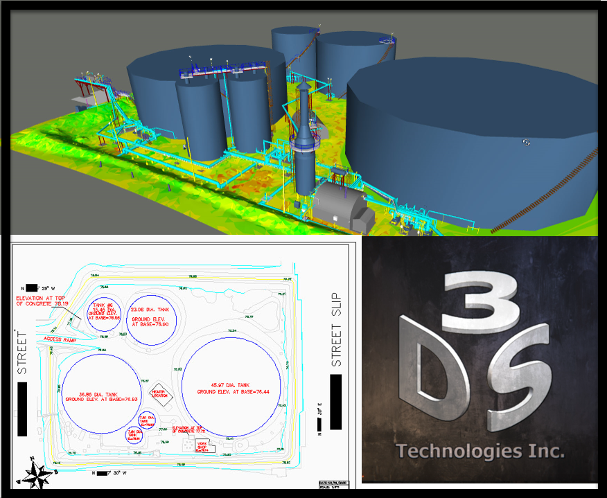
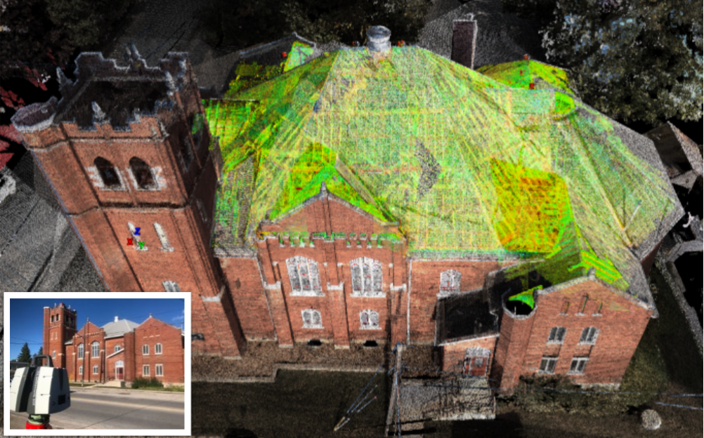
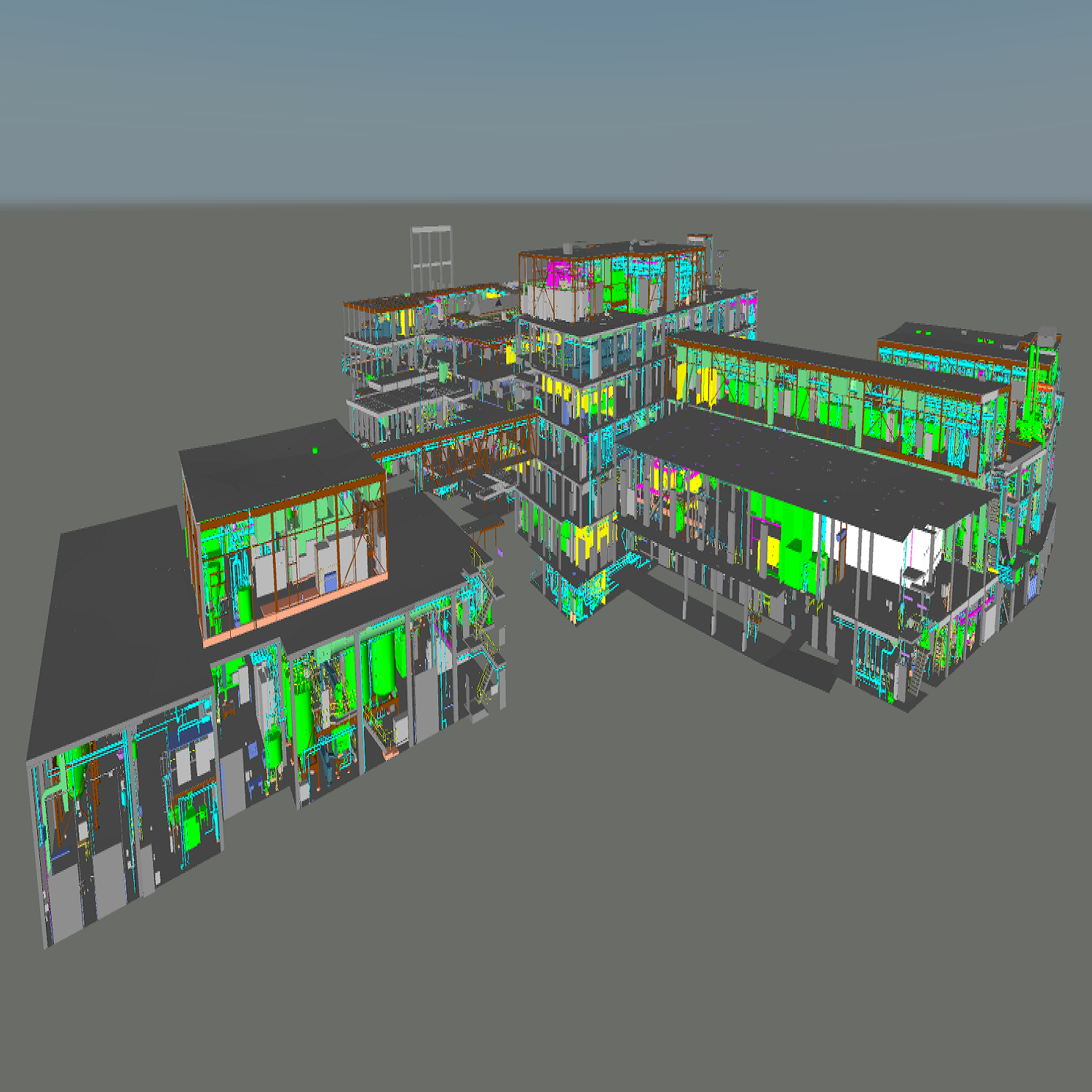
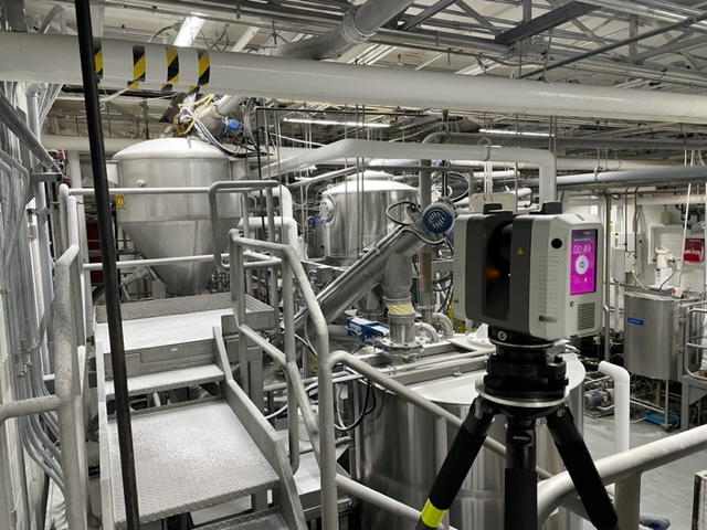
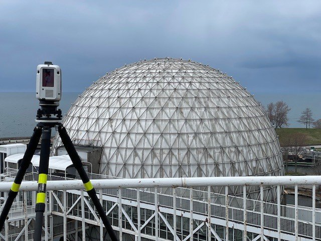
Our Gallery
Directory Of Services
- 3D Laser Scanning in Mississauga, ON
- 3D Laser Scanning in Etobicoke, ON
- 3D Laser Scanning in Brampton, ON
- 3D Laser Scanning in Scarborough, ON
- 3D Laser Scanning in Oakville, ON
- 3D Laser Scanning in Stoney Creek, ON
- 3D Laser Scanning in Hamilton, ON
- 3D Laser Scanning in Ottawa, ON
- 3D Laser Scanning in Kingston, ON
- 3D Laser Scanning in Barrie, ON
- 3D Laser Scanning in Windsor, ON
- 3D Laser Scanning in Kitchener, ON
- 3D Laser Scanning in Cambridge, ON
- 3D Laser Scanning in Waterloo, ON
- 3D Laser Scanning in Niagara Falls, ON
- 3D Laser Scanning in Calgary, AB
- 3D Laser Scanning in Edmonton, AB
- 3D Laser Scanning in Vancouver, BC
- 3D Laser Scanning in Victoria, BC
- 3D Laser Scanning in Kelowna, BC
- 3D Laser Scanning in Richmond, BC
- 3D Laser Scanning in Surrey, BC
- 3D Laser Scanning in Abbotsford, BC
- 3D Laser Scanning in Saskatoon, SK
- 3D Laser Scanning in Regina, SK
- 3D Laser Scanning in Winnipeg, MB
- 3D Laser Scanning in Halifax, NS
- 3D Laser Scanning in Miami, FL
- 3D Laser Scanning in Jacksonville, FL
- 3D Laser Scanning in Orlando, FL
- 3D Laser Scanning in Bradenton, FL
- 3D Laser Scanning in Tampa, FL
- 3D Laser Scanning in Fort Lauderdale, FL
- 3D Laser Scanning in Charlotte, NC
- 3D Laser Scanning in Houston, TX
- 3D Laser Scanning in Dallas, TX
- 3D Laser Scanning in Chicago, IL
- 3D Laser Scanning in Guelph, ON
- 3D Scanning in Mississauga, ON
- 3D Scanning in Etobicoke, ON
- 3D Scanning in Brampton, ON
- 3D Scanning in Scarborough, ON
- 3D Scanning in Oakville, ON
- 3D Scanning in Stoney Creek, ON
- 3D Scanning in Hamilton, ON
- 3D Scanning in Ottawa, ON
- 3D Scanning in Kingston, ON
- 3D Scanning in Barrie, ON
- 3D Scanning in Windsor, ON
- 3D Scanning in Kitchener, ON
- 3D Scanning in Cambridge, ON
- 3D Scanning in Waterloo, ON
- 3D Scanning in Niagara Falls, ON
- 3D Scanning in Calgary, AB
- 3D Scanning in Edmonton, AB
- 3D Scanning in Vancouver, BC
- 3D Scanning in Victoria, BC
- 3D Scanning in Kelowna, BC
- 3D Scanning in Richmond, BC
- 3D Scanning in Surrey, BC
- 3D Scanning in Abbotsford, BC
- 3D Scanning in Saskatoon, SK
- 3D Scanning in Regina, SK
- 3D Scanning in Winnipeg, MB
- 3D Scanning in Halifax, NS
- 3D Scanning in Miami, FL
- 3D Scanning in Jacksonville, FL
- 3D Scanning in Orlando, FL
- 3D Scanning in Bradenton, FL
- 3D Scanning in Tampa, FL
- 3D Scanning in Fort Lauderdale, FL
- 3D Scanning in Charlotte, NC
- 3D Scanning in Houston, TX
- 3D Scanning in Dallas, TX
- 3D Scanning in Chicago, IL
- 3D Scanning in Guelph, ON
- 3D Scan in Mississauga, ON
- 3D Scan in Etobicoke, ON
- 3D Scan in Brampton, ON
- 3D Scan in Scarborough, ON
- 3D Scan in Oakville, ON
- 3D Scan in Stoney Creek, ON
- 3D Scan in Hamilton, ON
- 3D Scan in Ottawa, ON
- 3D Scan in Kingston, ON
- 3D Scan in Barrie, ON
- 3D Scan in Windsor, ON
- 3D Scan in Kitchener, ON
- 3D Scan in Cambridge, ON
- 3D Scan in Waterloo, ON
- 3D Scan in Niagara Falls, ON
- 3D Scan in Calgary, AB
- 3D Scan in Edmonton, AB
- 3D Scan in Vancouver, BC
- 3D Scan in Victoria, BC
- 3D Scan in Kelowna, BC
- 3D Scan in Richmond, BC
- 3D Scan in Surrey, BC
- 3D Scan in Abbotsford, BC
- 3D Scan in Saskatoon, SK
- 3D Scan in Regina, SK
- 3D Scan in Winnipeg, MB
- 3D Scan in Halifax, NS
- 3D Scan in Miami, FL
- 3D Scan in Jacksonville, FL
- 3D Scan in Orlando, FL
- 3D Scan in Bradenton, FL
- 3D Scan in Tampa, FL
- 3D Scan in Fort Lauderdale, FL
- 3D Scan in Charlotte, NC
- 3D Scan in Houston, TX
- 3D Scan in Dallas, TX
- 3D Scan in Chicago, IL
- 3D Scan in Guelph, ON
- LiDAR in Mississauga, ON
- LiDAR in Etobicoke, ON
- LiDAR in Brampton, ON
- LiDAR in Scarborough, ON
- LiDAR in Oakville, ON
- LiDAR in Stoney Creek, ON
- LiDAR in Hamilton, ON
- LiDAR in Ottawa, ON
- LiDAR in Kingston, ON
- LiDAR in Barrie, ON
- LiDAR in Windsor, ON
- LiDAR in Kitchener, ON
- LiDAR in Cambridge, ON
- LiDAR in Waterloo, ON
- LiDAR in Niagara Falls, ON
- LiDAR in Calgary, AB
- LiDAR in Edmonton, AB
- LiDAR in Vancouver, BC
- LiDAR in Victoria, BC
- LiDAR in Kelowna, BC
- LiDAR in Richmond, BC
- LiDAR in Surrey, BC
- LiDAR in Abbotsford, BC
- LiDAR in Saskatoon, SK
- LiDAR in Regina, SK
- LiDAR in Winnipeg, MB
- LiDAR in Halifax, NS
- LiDAR in Miami, FL
- LiDAR in Jacksonville, FL
- LiDAR in Orlando, FL
- LiDAR in Bradenton, FL
- LiDAR in Tampa, FL
- LiDAR in Fort Lauderdale, FL
- LiDAR in Charlotte, NC
- LiDAR in Houston, TX
- LiDAR in Dallas, TX
- LiDAR in Chicago, IL
- LiDAR in Guelph, ON
- Building Information Modeling in Mississauga, ON
- Building Information Modeling in Etobicoke, ON
- Building Information Modeling in Brampton, ON
- Building Information Modeling in Scarborough, ON
- Building Information Modeling in Oakville, ON
- Building Information Modeling in Stoney Creek, ON
- Building Information Modeling in Hamilton, ON
- Building Information Modeling in Ottawa, ON
- Building Information Modeling in Kingston, ON
- Building Information Modeling in Barrie, ON
- Building Information Modeling in Windsor, ON
- Building Information Modeling in Kitchener, ON
- Building Information Modeling in Cambridge, ON
- Building Information Modeling in Waterloo, ON
- Building Information Modeling in Niagara Falls, ON
- Building Information Modeling in Calgary, AB
- Building Information Modeling in Edmonton, AB
- Building Information Modeling in Vancouver, BC
- Building Information Modeling in Victoria, BC
- Building Information Modeling in Kelowna, BC
- Building Information Modeling in Richmond, BC
- Building Information Modeling in Surrey, BC
- Building Information Modeling in Abbotsford, BC
- Building Information Modeling in Saskatoon, SK
- Building Information Modeling in Regina, SK
- Building Information Modeling in Winnipeg, MB
- Building Information Modeling in Halifax, NS
- Building Information Modeling in Miami, FL
- Building Information Modeling in Jacksonville, FL
- Building Information Modeling in Orlando, FL
- Building Information Modeling in Bradenton, FL
- Building Information Modeling in Tampa, FL
- Building Information Modeling in Fort Lauderdale, FL
- Building Information Modeling in Charlotte, NC
- Building Information Modeling in Houston, TX
- Building Information Modeling in Dallas, TX
- Building Information Modeling in Chicago, IL
- Building Information Modeling in Guelph, ON
Frequently asked questions
- How does point cloud data support environmental monitoring?
Point cloud data supports environmental monitoring by tracking terrain shifts, vegetation health, and erosion over time—providing objective, data-driven insights.
- How does LiDAR technology detect ground elevation changes?
LiDAR detects elevation changes using time-of-flight laser measurements that record height variations across terrain. This makes it a go-to tool for slope analysis, flood modeling, and large-scale infrastructure development projects.
- Can LiDAR data improve transportation route design?
LiDAR data refines transportation route design by mapping terrain elevation, slope, and vegetation density. This supports safer and more efficient highway and rail alignments.
- What’s the typical range of airborne mapping equipment?
Airborne mapping systems typically range from a few hundred meters to several kilometers depending on laser strength and conditions. High-end LiDAR sensors mounted on planes or drones can cover vast terrain efficiently.
- How is LiDAR improving environmental mapping across Jacksonville, FL and neighboring regions?
LiDAR mapping strengthens environmental research in Jacksonville, revealing land shifts, vegetation cover, and flood potential.